

@prewarnut

In developing the test route or “local loop” I have mapped out the most logical route on basis of the roads in place at the time (1916) along with local knowledge of the area having lived and worked there for a number of years and having driven almost all of the roads. What is clear are the towns that form the points of this polygon of a loop. All that is needed is to connect the dots. The terrain is primarily similar although in some places regrading has occurred. Obviously interstate and local highways did not exist but interestingly many roads remain in place, probably quite similar to where they were originally laid out. In some cases they have been widened or developed into a divided lane road. Names and route numbers have occasionally been changed. What I present is in most cases a probable representation and where assumptions are made I will share in italics to present transparency. While it will be impossible to fully substantiate the route with perfect certainty I also believe it is not possible to refute it either with certainty. The following, then, is what I believe occurred.
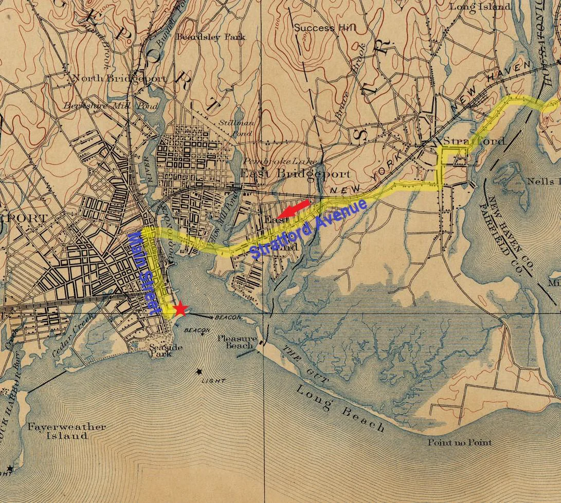
A test driver signed out the latest, freshly painted body on chassis and exited the Tongue Point factory turning right onto Main Street heading north. Today’s Main Street is bisected by the new sports arena. Interstate 95 looms overhead on a series of bridges. In the day the train yard would have been a few blocks up on the right with the station north of this, starting about where South Ave and Middle Ave would intersect – but this area no longer exists. The present station is north of this between State and John St.
While leaving the factory on Main street makes sense as an effective and brisk exit from the factory. There is documentation that trying to avoid the public was a concern, also probably avoiding accidents – and some did occur with the test cars - and thus exiting the dense part of the city quickly was probably a priority. Likely then a right turn onto Fairfield Avenue turning east to cross the Stratford Avenue bridge occurred. Note in the entire test loop the exit from the factory to Nichols poses the most difficult assessment as will be seen.
The East Side of Bridgeport has had changes, notably the entire city block structure south of Stratford Avenue was razed in the last decade. Then and now the second left is East Main Street. Likely this second left was selected to head north. The east side is flat. It has a number of square city blocks. This was chiefly residential in the day, probably another good reason to select this route. At the northern boundary is Boston Avenue – on a diagonal. The driver turned left to head northwest, and then the first right to head north onto Huntington Road. Of note the present intersection does not match the original map and may have been moved to the west slightly. After a half mile this presently merges with the continuation of East Main Street which was not present at the time.
Configuration of roads near Beardsley Park have changed. Selecting a right fork to head northeast becomes present day Huntington Turnpike. This is most probable. While not selecting this could have occurred, it would have required a right onto Unity Road in the Nichols section of Trumbull and this poses an awkward right and sharp left around the triangular green at Nichols. While possible (I have done it) it seems more straightforward that Huntington turnpike (right fork) was selected.
Approaching the green at Nichols, again selecting the right fork to take Shelton Road was probable. Alternately staying on the left fork - Huntington Turnpike - arrives one at Huntington. This requires a counter-clockwise movement around that green, also with a sharp left turn and the whole just delays the arrival in Shelton and Derby. Today it has traffic lights making it slower but it still seems unnecessary. From here the route is much more straightforward.
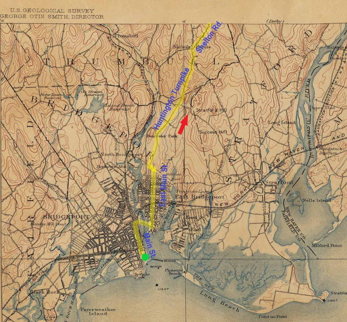
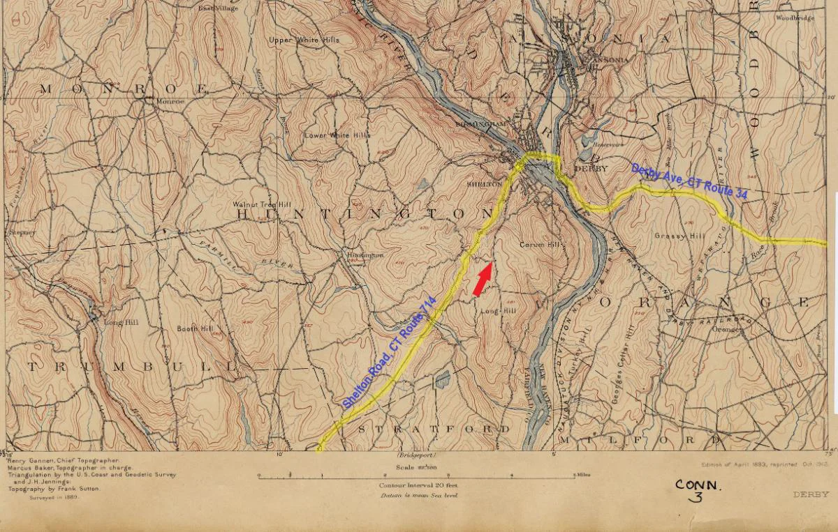
By now the driver has driven steadily from 20 feet above sea level in the east side of Bridgeport to 80 and then down to 60 feet alongside Beardsley Park in the north end of the city. A steady climb to 100 and then 250 feet at the fork in Nichols occurred in the span of 1 mile (100-250 feet). Just northeast of the green in Nichols a peak of 300 feet is reached followed by a long downhill with a 60 foot drop in ½ mile and another 60 foot drop in 1/8 mile. The road runs somewhat level at near 180 to 200 feet for awhile until nearing Shelton when a drop of 80 feet in 2/10s of a mile and then another 60 feet at another 2/10s of a mile occurs, finally reaching the city elevated around 40 feet or so approaching Shelton on what becomes Center Street. Likely a left onto Howe and then a right onto Canal street occurred. The driver undoubtedly crossed the Housatonic River on the Derby-Shelton Bridge to reach Derby taking a right onto Main Street, present CT Route 34 east.
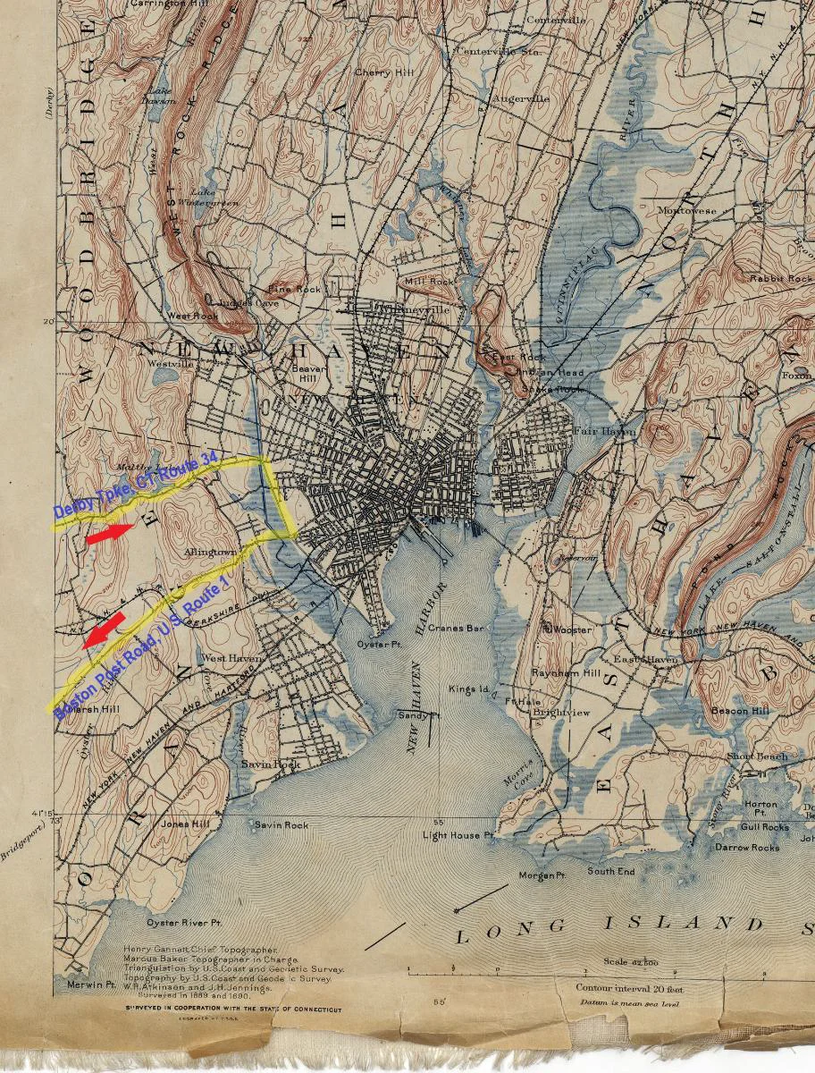
One more bridge would bring the driver to Derby Avenue on the east shore of the confluent Naugatuck River. A right would continue on Route 34 east. Here remains probably the original road just parallel on the east side, “Old New Haven Avenue” and probably this was used, now merging onto Route 34. The initial portion of road appears similar to the old maps with an 80 foot rise in ½ mile. Further up some regrading may have occurred and the road has been widened. The grade is more gentle at 100-200 feet continuing through the countryside through Orange, CT. Near the Maltby Lakes, a brisk drop of 80 feet in 1/10 mile occurs. Another elevation drop follows, slightly less dramatic taking the roadway down to near sea level entering New Haven.
At this point a trip into the center of New Haven makes no sense. The city is a matrix of city blocks, some narrow and with the city center towards the eastern side adjacent to the harbor no purpose is served bringing test equipment in that far for the same rationale of exiting Bridgeport as briskly as possible makes sense. New Haven had trolley lines, horse carts, pedestrians and it would be wise to avoid all this. I believe a right turn to head south on present day Ella Grasso Blvd, CT Route 10 and then a right onto the Boston Post Road, U.S. Route 1 heading southwest was the directive. The Berkshire line of the RR was crossed but these tracks and track bed no longer exist. From here travel would be level and along the coast. The next obstacle was Milford.
Today Milford has interstate 95 running north of the town center. As well a bypass road that carries U.S. Route 1 also rings around the historic center. In arriving at Milford continuing on Cherry Street heading west, crossing Prospect Street at the light and selecting River Street heading diagonally southwest makes the most sense in order to reach the east end of the long town green. This is how to get there in the present day and I believe was the manner in which the driver took. While there is a photo of a Locomobile headed west in front of the historic Robert Treat Bridge in Milford it is very awkward to get a car placed there unless instead of Cherry Street the driver turned left on Gulf Street and then right onto New Haven Avenue to cross that bridge (but today it becomes one way just west of the bridge forcing drivers north and around a block to reach the green). It is a longer route but in any case taking Broad Street west along the green must have occurred. This becomes Bridgeport Avenue and takes a course towards Bridgeport of course. Next however is Stratford.
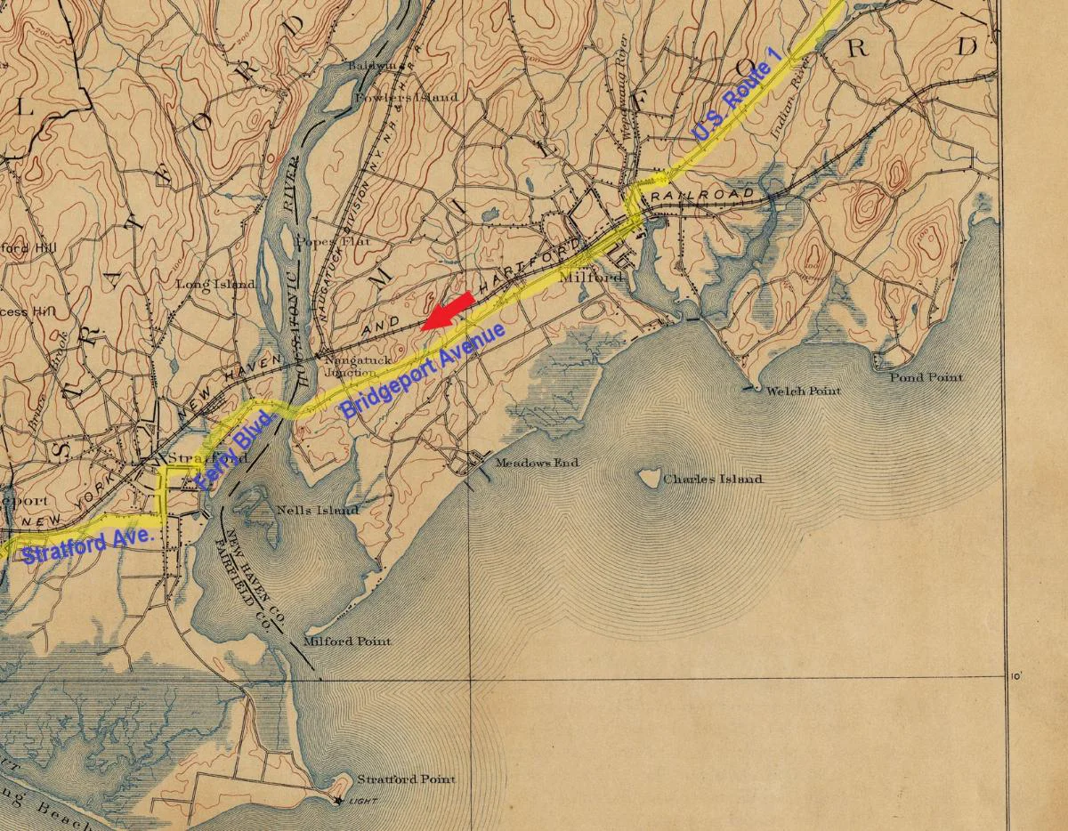
In Stratford today, in contrast to Milford, the interstate highway runs right through it (mostly over it). A crossing on the Washington Bridge eventually to Ferry Blvd. looks obvious. Some interruption of original grading and side-streets is inevitable but exiting the town center to the west and onto Stratford Avenue, CT Route 130 would take the driver to the east end of Bridgeport. A trip over the Yellow Mill Bridge and back across the Stratford Avenue bridge would get back to Main Street downtown Bridgeport. A left to head south a few blocks to Tongue Point would complete the day.
As can be seen because there are not many parallel routes to each destination on the loop this scenario is highly probable. Other than getting bogged down over each left and right taken within a few city areas the overall shape of the loop can be shown. While many processes of early design and testing are lost to time it is interesting that this may provide enlightenment on a standardized route Locomobile used - potentially for many years.
Many thanks to Frank Ittenbacher for asking the Bridgeport Library, History Center Collection to post on-line.
To join in the conversation, you must be a club member.
You’re welcome to read and like every post. Members can reply and start topics of their own.